Luigi Pirelli
Luigi Pirelli
I'm using the GPIO lcd and added button shortcut to run LCD-hdmi script and works correclty, but LCD35-show run gti clone and build everytime also if already done. would be...

Sorry if I'm sending a wrong WKT string (generated with entwine project) In Potree project I face exception doing conversion with: proj4.defs("pointcloud", projection); const transform = proj4("pointcloud", "WGS84"); with this...
**Describe the bug**: ... During an exception handling capture_exeption fail to send data and as result transaction is aborted. Seems the problem is decoding the data payload (memoryview type) to...
as in the photo the content of pull down many are not correctly localised 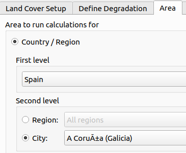 See City when "Coruña" is selected
Not clear to me if the error is realted to Potree or how entwine create the CRS WKT in al ept*.json of the main build in in 0.json in ept-sources/...
# Description Shortcut - Story: https://app.shortcut.com/cartoteam/story/320183 - Autolink: [sc-320183] port all possible JS code to SQL ## Type of change - Refactor # Acceptance Please describe how to validate the...
# Description Shortcut - Story: https://app.shortcut.com/cartoteam/story/320182 - Autolink: [sc-320182] JS implementation of the new alg of polyfill. No SQl implementation doe to SF limitations and problems with subqueries and FLATTEN...
Hi, I think would be useful to publish this plugin in the official qgis repo, in this way you can find more people interested in a similar plugin and can...
Compound SRS remain unsupported but at least no parsing error. Vertical datum is tripped leaving only the horizontal part. would fix https://github.com/proj4js/proj4js/issues/282 Note: I didn't find a way to leave...
Hi it's not an issue but an invitation to share/add this cookbook within the QGIS documentation regards