Kevin
Kevin
A polygon is provided as an array of points, which is in geojson format. `wicket.wrtie()` incorrectly returns a `POINT( ... ) ` rather than a `POLYGON ( ... ) `...

**This works** `wicket.read('{"coordinates": [[[30, 10], [10, 20], [20, 40], [40, 40], [30, 10]]], "type": "Polygon"}');` **This does not work** `wicket.read('{"coordinates" : [[[30, 10], [10, 20], [20, 40], [40, 40], [30,...
Hi, ES6 does not use default values when sending `null` as a parameter. See [MDN](https://developer.mozilla.org/en-US/docs/Web/JavaScript/Reference/Functions/default_parameters) > Default function parameters allow formal parameters to be initialized with default values if no...
Hi, using double colon in variables gets picked up in syntax highlight but does not grey out the submit button like in other cases where the request is malformed 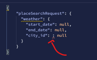...
Hi, It would be great if the explorer would be able to dish out multiple requests at once. Maybe not to the extent of [artillery](https://www.npmjs.com/package/artillery), but maybe a `Repeat request...
May I suggest another operation to determine touching containers? eg. `geo_lookup.getTouchingContainers(geometry) ` => returns touching features `geo_lookup.forEachTouchingContainer(geometry) ` => iterate touching features [Link to geojson.io to paste the following JSON](http://geojson.io)...
Hi, This LineString `LINESTRING(18.6233900000 -33.8963590000 0, 18.6234010000 -33.8966330000 0, 18.6234090000 -33.8967650000 0, 18.6234420000 -33.8973360000 0, 18.6234490000 -33.8974650000 0, 18.6234790000 -33.8980180000 0, 18.6234860000 -33.8981470000 0, 18.6235040000 -33.8985640000 0)` used like this...
#### Environment details 1. Place FindPlace - NodeJS Client 2. MacOS m1 3. "@googlemaps/google-maps-services-js": "3.3.28" #### Steps to reproduce 1. Make a FindPlace call with fields `url` and `photo` as...
Hi, I've recently spent some time to import the better quality OSM boundary administrative data. I've also been able to collate the correct countries and regions, handling each new database...
Hi, the region names for Ivory Coast are invalid. The expectation is to have the region name and not the country name. Usage ```javascript const geojsonPlaces = require("geojson-places"); geojsonPlaces.getRegionsByCountryAlpha2('CI'); ```...