leaflet-multispectral
 leaflet-multispectral copied to clipboard
Multispectral color manipulation and processing (NDVI etc) for Leaflet image overlays with pure JavaScript in Image Sequencer
Leaflet.Multispectral
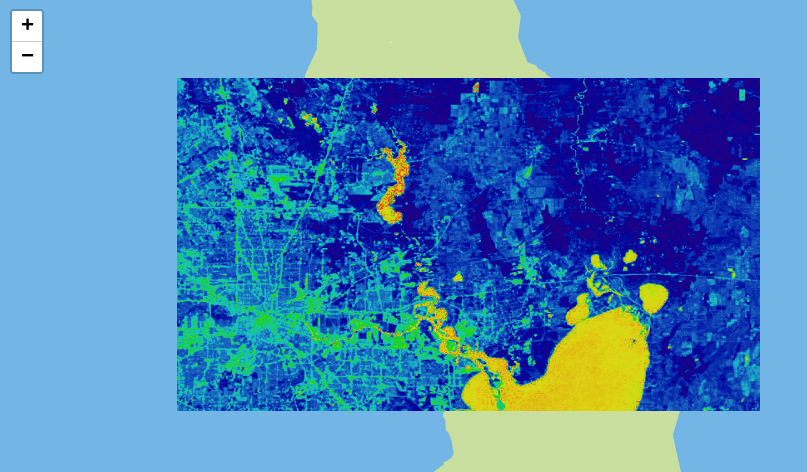
This Leaflet plugin provides multispectral channel manipulation and processing tools (such as NDVI or other remote sensing methods) for Leaflet tile and image layers using pure client-side JavaScript. It uses image-sequencer and was developed by Public Lab.
It is available as a node module as leaflet-multispectral.
Also see Leaflet.TileFilter, which is a re-implementation of this library for on-the-fly TileLayer filtering.
This library was made possible in part by NASA's AREN project.
Usage
See the demo for basic usage: https://publiclab.github.io/leaflet-multispectral/
// create an image
var img = L.imageOverlay('example.jpg', [[29.0, -118.2],[29.1, -118.4]]);

// apply NDVI equation to the image, and then a colormap:
img.filter('ndvi,colormap');

img.addTo(map);
To revert the image to it's previous state, use:
img.revert();
For more complex commands, you can use JavaScript expresssions, in the following format:
img.filter('dynamic{red:R*2|green:B|blue:B/2}');
In this example, we're using Image Sequencer's dynamic module to set the displayed RGB values individually, with the expressions R*2, B, and B/2, respectively.
Image Sequencer
Commands you can pass into the filter are extremely flexible; they are Image Sequencer string syntax (full object notation coming soon). Read about Image Sequencer and how to use it here:
https://github.com/publiclab/image-sequencer
Using the visual editor, you can develop a command string to pass into this filter:
https://sequencer.publiclab.org
Image Sequencer is implemented in pure JavaScript, and is under development; we expect optimizations as well as worker threads and WebAssembly to improve performance in upcoming versions.
About Multispectral imagery
Learn about multi-band imagery, some of it's uses at this great blog post by Charlie Lloyd of Mapbox:
https://blog.mapbox.com/putting-landsat-8s-bands-to-work-631c4029e9d1
Here's some sources of Landsat 8 data:
- https://www.mapbox.com/bites/00145/
- https://aws.amazon.com/blogs/aws/start-using-landsat-on-aws/
Here's more on NDVI and DIY techniques to collect multi-band imagery: https://publiclab.org/infragram