Progress on quests?
On Tue, Jul 12, 2022 at 1:30 PM UnixPhonez @.***> wrote:
streetcomplete like quests would be quite nice
— Reply to this email directly, view it on GitHub https://github.com/bryceco/GoMap/issues/590#issuecomment-1182595784, or unsubscribe https://github.com/notifications/unsubscribe-auth/AL55QOQ2NWQQQ3ABPA7J4S3VTX5YJANCNFSM5QTXW5EQ . You are receiving this because you authored the thread.Message ID: @.***>
I believe that they were planned, but they weren’t added.
I initially hoped to have a semi-automated way of importing the quest database from StreetComplete into this project. After a lot of work having a quality working result was still too far off, and I abandoned the idea. However I'm restarting the Quest implementation by providing only a minimal number of quest types, where each one can be hand-crafted. I'm going to start with just a handful:
- Sidewalk surface (super popular in StreetComplete)
- Building type
- Telephone number for businesses
Once those are satisfactory then I'll start work on expanding the list. Please reply here if you have a favorite quest that you'd like to see implemented. Thanks!
The opening hours quest is maybe one of the less commonly used ones, but mappers in my area have really taken to it, and it’s a nice way of showing off Go Map!!’s opening hours recognition feature. 🙂
Thanks for sharing this update, @bryceco, that sounds great!
UI:
Are you working towards …
- a SC-quest-type of UI (pins on the map represent questions; clicking a pin provides a UI to collect answers to update the map data).
- Or towards the new SC-overlay-type of UI (map elements are highlighted on the map specified colors according to the selected overlay; clicking the highlighted map element provides the UI (nearly same UI)).
Personally, I would prefer the overlay-type UI.
Quests:
Please reply here if you have a favorite quest that you'd like to see implemented. Thanks!
The three starter Quests sound like a good start. Especially if you are looking into tackling all data types right away line, area, data completion / points).
Personally, a group of us is interested in data on bike infrastructure. For example:
- Highlight certain roads (pre filtered for those that are unrealistic) if they have no information on bike infrastructure (no becomes an important information in this case)
- Highlight all roads with bike infrastructure (including no) with a check_date < 15 month
- Add width to roads (mapped separately and mapped on the centerline) for (main lane, bike lane, sidewalk)
- Add surface and smoothness (mapped separately and mapped on the centerline) for (main lane, bike lane, sidewalk)
I'm using pins to indicate quests. I realize that makes things more difficult for your use-case where you're primarily looking at highway features, but it's the simplest way to implement quests without interfering with normal use of the app (e.g. it would be confusing if users could no longer use the regular editing features because tapping brought up the quest instead). It's possible we can revisit that later on.
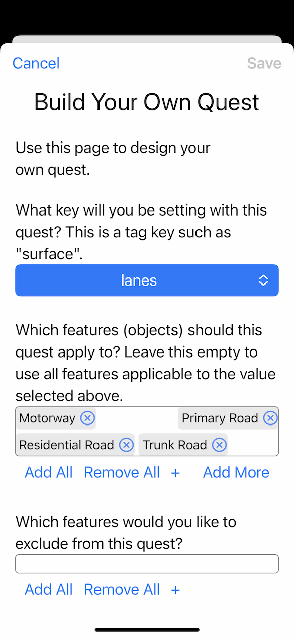
I'm trying to make it easy for users to define their own quests. For things like check_date and value=no they will probably have to be built-in quests.